Western Ghats starts in Tamil Nadu, at the southern tip of India. The
mountain with a special nomenclature at Kanyakumari, Marunthuvazh Malai, which
is abundant with herbal medicines, has its own myths and fables. It runs
through Kerala, Karnataka, Goa, Maharashtra and Gujarat. The length of the
mountain range is around 1,600 km. This Western Ghats are older than the
Himalayas. The Ghats play a vital role in the monsoon of the subcontinent,
modulating the winds and rains from Arabian Sea.
There are many highways pass through Western Ghats, it is also known for
many mountain passes, mainly connecting the western coast of India with the
mainland. The Palakkad Mountain pass is one among the passes in the Western
Ghats, that has a highway and also a clear gap of mountains for about 30 to 40
kms.
Recently, I
developed a strong interest to know about the Palakkad Mountain Pass or the
Palakkad Gap. The National Highway from Thrissur to Coimbatore passes through
Kuthiran Mountains in the Western Ghats via Palakkad. Once the road comes to
the other side of the Kuthiran Hills, the Palakkad Gap starts. I used to travel
in this road since 1992. It was a nightmare for many drivers to cross the
Kuthiran Mountains. The mountain is known for regular accidents. The breakdown
of heavy vehicles on the ghat roads, and reckless private buses that ply
between towns often cause problems on this, less than 3 km, mountain road. A
couple of times, I also experienced traffic jams. There is a temple in the
mountain that also causes traffic jams at times, since many gullible drivers
like to offer prayers in the temple, parking the vehicles on the ghat road. The gullible drivers put trust in their gods rather than trusting their own skills and traffic rules. Now
it is hassle-free, thanks to the tunnels and the new highway.
Fortunately, there is no toll plaza at the entrance of the tunnels, to collect money from every vehicle that passes the tuneel, as it is the custom today in India by NHAI. However, please be watchful there is Panniyankara toll plaza 9 km away from the tunnel. There are plenty of speed cameras on the road, be aware... I am not talking here about highways, tunnels or the daytime robbery at toll plazas; rather, I want to talk something about the Palakkad Mountain Pass.
My interest intensified after my desire to spend my retirement in the gap, to enjoy the constant moist air that comes from the Arabian Sea and also to enjoy the beauty of the Western Ghats.
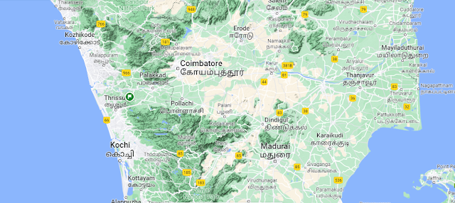
The Palakkad
Mountain Gap is clearly visible in the Google map. I am not a scholar in the
field of geography to explain the topography of this mountain gap or the
Western Ghats. However, my interest led me to do some readings on this
interesting land space. The mountain gap has a width of about 20 to 40 km that divides the
Western Ghats into two - Annamalai Hills range in the south, the Nilgiris Hills
range in the north. The gap can be seen from Nelliyampathy hills (which are
known for good trekking trails) in the southern Western Ghats and the
Malampuzha Dam near Palakkad on the northern side of the Western Ghats. The
scholars differentiate the small forests here and there seen in the Palakkad
Gap as dry evergreen forests as against the tropical rainforest
of the Western Ghats.
At present Bharathapuzha River flows through this gap. The river originates in Thirumoorthy Dam, Tamil Nadu, and from many small rivers that originate in the Annamalai hills. It flows westward into Kerala. Some Kerala fanatics, in order not to accept that Bharathapuzha, a major river in Kerala, originates in Tamil Nadu, claim that it originates in Munnar in Kerala. Well, let us not debate on this issue.
According to some geography researchers, there is a similarity between the Palakkad gap and Madagascar. Due to volcanic activity in the sea, Madagascar drifted away further down south. Some other scholars claim that some ancient river or sea incursion might have caused this gap. They further argue the pieces of evidence of different species that live in the southern and northern parts of the Western Ghats. Some argue that this gap was formed by a hit from an asteroid a few million years ago. Well, all happened millions of years ago.
The regular winds from the Arabian Sea (western side of India) pass through this mountain gap in greater velocity that made Coimbatore the Manchester of South India. Many Cotton Mills thrive at Coimbatore, Tirupur etc on the Tamil Nadu side because of the winds coming from the Arabian Sea through the gap. From my visits to many cotton mills, I understand that the cotton dust primarily from fiber fragments is naturally carried away by these winds that funnel through the mountain gaps. Now there are many windmills erected in this locality to generate electricity.
Archeological Survey of India has identified a lot of Megalithic findings in this mountain gap. Most of these places are filled with rubber plantations that becomes a hindrance to new excavations. Nemmara, Kundalam, Kairady and Vellarkulum, Thiruvilwamala, Pazhayannur, Machad, Porkkalam, Cheramanangad, Anakkara in the Gayathri River - Bharathapuzha basins are known for these ignored megalithic structures. Though only few of them are excavated, scientists argue that the megalithic structures exist in these places because of the significance of the mountain gap. The iron objects found in Pazhayannur and Tiruvilwamala in the Gayathri River basin are very ancient materials. The megalithic Cist burials of Palakkad Gap show more similarities with the burial types of Tamil Nadu, especially those from Coimbatore, Palani and Erode regions.
Another
interesting thing I would like to mention here is, the scientists have found DNA difference
between the elephants of the Northern Western Ghats, in the
Nilgiris side (after the Palakkad gap) and, those live in the southern part of
the Western Ghats. Interesting to know.

